|
search place name
|
||
Wategas (Timor Timur, East Timor)Wategas is a town in the Timor Timur region of East Timor. An overview map of the region around Wategas is displayed below.
regional and 3d topo map of Wategas, East Timor ::

Wategas airports ::
The nearest airport is DIL - Dili Presidente Nicolau Lobato Intl, located 39.2 km north east of Wategas.
Nearby towns ::
Glai (2.0km south west) //
Uluana (2.2km east) //
Siamado (2.3km south west) //
Raimeda (3.2km south west) //
Nunulisa (3.8km north) //
Ceres (4.0km south east) //
Sare (4.1km south) //
Mauuno (4.1km north west) //
Dirihatilau (4.1km south east) //
Pandavou (4.2km north west) //
Watuadalara (4.2km north west) //
Poelete (4.3km south east) //
Direma (4.5km east) //
Goulete (4.5km south west) //
Batubeleter (4.7km north) //
Oekiar (4.9km south west) //
Pelelor (5.1km north east) //
Oebola (5.2km south west) //
Esloso (5.5km north east) //
Irlelo (5.4km west) //
Caisoro (5.5km east) //
Kaikasa Vou (5.5km north) //
Madehoau (5.5km south) //
Kakamata (5.6km south) //
Vatuvei (5.7km north west) //
Kaikasa (5.8km north) //
Lebuhae (6.1km north east) //
Darulema (6.4km north) //
Darolema (6.6km north) //
[all distances 'as the bird flies' and approximate] 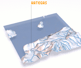 Places with similar names to Wategas, East Timor ::
Disclaimer :: Information on this page comes without warranty of any kind |
||
|
Where is Wategas? Elevation and coordinates ::
Latitude (lat): 8°43'22"S Longitude (lon): 125°12'56"E
Elevation (approx.): 92m (map arrows pan, magnifying glasses zoom) |
||
|
Visiting Wategas? Hotel/Accommodation ::
Book a hotel in Wategas Travel Guide ::
Buy a travel guide for East Timor rental cars ::
car rental offers GPS waypoint ::
download a GPX waypoint (PoI) of Wategas for your GPS receiver
|
||