|
search place name
|
||
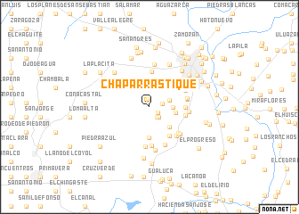
Chaparrastique (San Miguel, El Salvador)Chaparrastique is a town in the San Miguel region of El Salvador. An overview map of the region around Chaparrastique is displayed below.
regional and 3d topo map of Chaparrastique, El Salvador ::
Chaparrastique airports ::
The nearest airport is SAL - San Salvador El Salvador Intl, located 89.7 km west of Chaparrastique.
Other airports nearby include TGU - Tegucigalpa Toncontin Intl (129.7 km north east), Nearby towns ::
El Casco (1.0km north) //
Los Berríos (1.2km south east) //
El Ciprés (1.6km south east) //
Los Rodas (1.6km east) //
El Copante (1.7km south east) //
Santa Lucía (2.4km north) //
Los Sánchez (2.5km east) //
El Niño (2.9km east) //
Las Lomitas (3.3km east) //
Las Cocinas (3.6km south east) //
Buena Vista (3.8km south) //
Guadalupe (4.4km north) //
El Caimito (4.4km south east) //
Las Lomitas (4.5km north east) //
Alto del Llano (4.4km east) //
Las Playitas (4.5km east) //
La Joya (4.7km east) //
La Cruzadilla (4.8km south) //
Monte Grande (4.7km east) //
Los Portillos (4.8km south east) //
La Puerta (4.9km south east) //
La Cuesta (4.8km north east) //
El Amate (5.0km south) //
La Presa (4.9km east) //
La Morita (5.1km south) //
Los Sorto (5.1km south east) //
El Amate (5.3km north) //
San Carlos (5.4km south) //
La Cruz (5.8km north east) //
[all distances 'as the bird flies' and approximate] 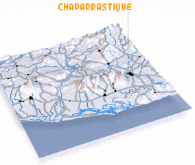 Places with similar names to Chaparrastique, El Salvador :: Disclaimer :: Information on this page comes without warranty of any kind |
||
|
Where is Chaparrastique? Elevation and coordinates ::
Latitude (lat): 13°25'42"N Longitude (lon): 88°13'38"W
Elevation (approx.): 345m (map arrows pan, magnifying glasses zoom) |
||
|
Visiting Chaparrastique? Hotel/Accommodation ::
Book a hotel in Chaparrastique Travel Guide ::
Buy a travel guide for El Salvador rental cars ::
car rental offers GPS waypoint ::
download a GPX waypoint (PoI) of Chaparrastique for your GPS receiver
|
||