|
search place name
|
||
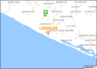
Las Hojas (La Paz, El Salvador)Las Hojas is a town in the La Paz region of El Salvador. An overview map of the region around Las Hojas is displayed below.
regional and 3d topo map of Las Hojas, El Salvador ::
Las Hojas airports ::
The nearest airport is SAL - San Salvador El Salvador Intl, located 8.6 km north of Las Hojas.
Other airports nearby include GUA - Guatemala City La Aurora (209.3 km north west), TGU - Tegucigalpa Toncontin Intl (212.4 km east), Nearby towns ::
San Antonio (2.2km north) //
El Cocal (2.2km north) //
El Pimiental (2.2km west) //
Marcelino (2.5km south east) //
El Porvenir (3.1km north) //
El Fraile (3.2km east) //
El Achiotal (5.1km north) //
San Francisco El Porfiado (5.0km east) //
Santa Emilia (5.2km north east) //
San José (5.9km north) //
Las Isletas (5.9km north east) //
San Francisco Amatepe (7.0km north) //
Los Blancos (7.6km south east) //
Santa Rosa (8.4km north east) //
San Felipe (8.4km north east) //
El Amatal (8.9km east) //
El Llano (8.9km east) //
Las Guarumas (9.0km north east) //
La Esmeralda (10.9km north west) //
El Porvenir (10.9km north west) //
[all distances 'as the bird flies' and approximate] 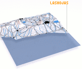 Places with similar names to Las Hojas, El Salvador ::
Disclaimer :: Information on this page comes without warranty of any kind |
||
|
Where is Las Hojas? Elevation and coordinates ::
Latitude (lat): 13°21'49"N Longitude (lon): 89°2'47"W
Elevation (approx.): 4m (map arrows pan, magnifying glasses zoom) |
||
|
Visiting Las Hojas? Hotel/Accommodation ::
Book a hotel in Las Hojas Travel Guide ::
Buy a travel guide for El Salvador rental cars ::
car rental offers GPS waypoint ::
download a GPX waypoint (PoI) of Las Hojas for your GPS receiver
|
||