|
search place name
|
||
Toluca (La Libertad, El Salvador)Toluca is a town in the La Libertad region of El Salvador. An overview map of the region around Toluca is displayed below.
regional and 3d topo map of Toluca, El Salvador ::

Toluca airports ::
The nearest airport is SAL - San Salvador El Salvador Intl, located 17.5 km east of Toluca.
Other airports nearby include GUA - Guatemala City La Aurora (189.0 km north west), Nearby towns ::
Hacienda Melara (3.6km north) //
Melara (3.6km north) //
El Pulido (4.0km north west) //
Cerco de Piedra (4.0km north east) //
Santa Cruz (4.0km north east) //
Cangrejera (4.4km east) //
San Diego (4.8km north west) //
San Alfredo (5.7km east) //
Plan del Mango (6.5km north) //
El Palomar (8.1km north west) //
Amayón (8.8km north east) //
Santa Lucía La Barranca (9.1km north east) //
Planes de Las Delicias (10.1km north east) //
[all distances 'as the bird flies' and approximate] 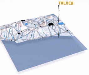 Places with similar names to Toluca, El Salvador ::
Disclaimer :: Information on this page comes without warranty of any kind |
||
|
Where is Toluca? Elevation and coordinates ::
Latitude (lat): 13°27'4"N Longitude (lon): 89°13'2"W
Elevation (approx.): 6m (map arrows pan, magnifying glasses zoom) |
||
|
Visiting Toluca? Hotel/Accommodation ::
Book a hotel in Toluca Travel Guide ::
Buy a travel guide for El Salvador rental cars ::
car rental offers GPS waypoint ::
download a GPX waypoint (PoI) of Toluca for your GPS receiver
|
||