|
search place name
|
||
Chiquihuil (Huehuetenango, Guatemala)Chiquihuil is a town in the Huehuetenango region of Guatemala. An overview map of the region around Chiquihuil is displayed below.
regional and 3d topo map of Chiquihuil, Guatemala ::

Chiquihuil airports ::
The nearest airport is TAP - Tapachula Intl, located 81.1 km south west of Chiquihuil.
Other airports nearby include TGZ - Tuxtla Gutierrez Angel Albino Corzo (162.6 km north west), CBV - Coban (174.6 km east), GUA - Guatemala City La Aurora (188.2 km south east), Nearby towns ::
Las Flores (3.7km north) //
Horno de Cal (4.1km south east) //
La Laguna (4.0km south west) //
Oaxaqueño (4.0km north west) //
Caníbal (5.6km south) //
El Rodeo (5.7km west) //
Agua Dulce (7.4km north) //
El Bojonal (7.6km north) //
El Boquerón (7.6km north) //
Cuá (8.1km south east) //
Sabunul (8.1km south east) //
Platanillo (8.0km north west) //
Cuilco (9.1km south east) //
Agua Sembrada (9.1km south east) //
Vuelta Grande (9.1km south east) //
Río Blanco (10.3km north west) //
[all distances 'as the bird flies' and approximate] 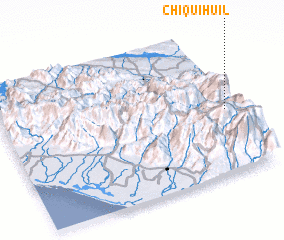 Places with similar names to Chiquihuil, Guatemala ::
// Chukheli (UA)
// Sheykh-Eli (UA)
// Chāh Khūlū (IR)
// Chāy Khāleh (IR)
// Chacahoula (US)
// Cheukhāli (BD)
// Cheukhāli (BD)
// Tiākhāli (BD)
// Chikhali (IN)
// Sheakhala (IN)
Disclaimer :: Information on this page comes without warranty of any kind |
||
|
Where is Chiquihuil? Elevation and coordinates ::
Latitude (lat): 15°27'0"N Longitude (lon): 92°2'0"W
Elevation (approx.): 2306m (map arrows pan, magnifying glasses zoom) |
||
|
Visiting Chiquihuil? Hotel/Accommodation ::
Book a hotel in Chiquihuil Travel Guide ::
Buy a travel guide for Guatemala rental cars ::
car rental offers GPS waypoint ::
download a GPX waypoint (PoI) of Chiquihuil for your GPS receiver
|
||