|
search place name
|
||
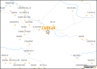
Cubejá (Alta Verapaz, Guatemala)Cubejá is a town in the Alta Verapaz region of Guatemala. An overview map of the region around Cubejá is displayed below.
regional and 3d topo map of Cubejá, Guatemala ::
Cubejá airports ::
The nearest airport is CBV - Coban, located 67.6 km south west of Cubejá.
Other airports nearby include GUA - Guatemala City La Aurora (150.6 km south west), SAP - San Pedro Sula La Mesa Intl (211.6 km east), BZE - Belize City Philip S W Goldson Intl (255.7 km north east), Nearby towns ::
El Achiotal (4.0km north west) //
Setzí (4.1km north east) //
Chajmaic Cajbón (6.6km north west) //
Chajmaic (8.0km south west) //
La Ceiba (8.0km north west) //
El Azufre (9.0km north west) //
La Caoba (9.0km north west) //
Semococh (10.3km south west) //
[all distances 'as the bird flies' and approximate] 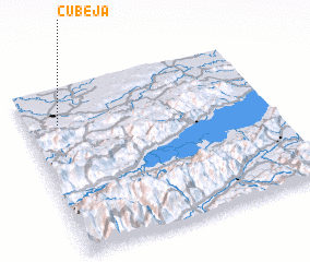 Places with similar names to Cubejá, Guatemala ::
Disclaimer :: Information on this page comes without warranty of any kind |
||
|
Where is Cubejá? Elevation and coordinates ::
Latitude (lat): 15°47'0"N Longitude (lon): 89°52'0"W
Elevation (approx.): 173m (map arrows pan, magnifying glasses zoom) |
||
|
Visiting Cubejá? Hotel/Accommodation ::
Book a hotel in Cubejá Travel Guide ::
Buy a travel guide for Guatemala rental cars ::
car rental offers GPS waypoint ::
download a GPX waypoint (PoI) of Cubejá for your GPS receiver
|
||