|
search place name
|
||
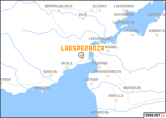
La Esperanza (Izabal, Guatemala)La Esperanza is a town in the Izabal region of Guatemala. An overview map of the region around La Esperanza is displayed below.
regional and 3d topo map of La Esperanza, Guatemala ::
La Esperanza airports ::
The nearest airport is SAP - San Pedro Sula La Mesa Intl, located 119.0 km east of La Esperanza.
Other airports nearby include CBV - Coban (150.2 km west), TEA - Tela (165.9 km east), GUA - Guatemala City La Aurora (199.7 km south west), BZE - Belize City Philip S W Goldson Intl (224.0 km north), Nearby towns ::
Castillo de San Felipe (1.8km east) //
Fronteras (2.6km north east) //
Las Delicias (2.6km north east) //
Jacoló (4.0km south west) //
Colorado (4.0km south east) //
La Bacadilla (5.1km north east) //
La Esmeralda (5.1km north east) //
Santa Isabel (5.7km east) //
Lechuga (5.8km south) //
Barra San Marcos (6.5km south east) //
El Coco (6.5km north east) //
Sumache (8.0km south west) //
Camelias (8.0km north east) //
[all distances 'as the bird flies' and approximate] 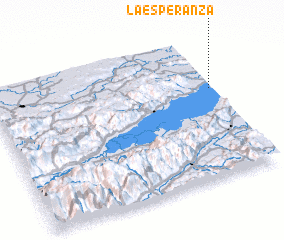 Places with similar names to La Esperanza, Guatemala ::
// La Esperanza (PH)
// La Esperanza (PH)
// La Esperanza (PA)
// La Esperanza (PA)
// La Esperanza (PA)
// La Esperanza (PA)
// La Esperanza (PA)
// La Esperanza (CU)
// La Esperanza (CU)
// La Esperanza (CU)
Disclaimer :: Information on this page comes without warranty of any kind |
||
|
Where is La Esperanza? Elevation and coordinates ::
Latitude (lat): 15°38'0"N Longitude (lon): 89°1'0"W
Elevation (approx.): 11m (map arrows pan, magnifying glasses zoom) |
||
|
Visiting La Esperanza? Hotel/Accommodation ::
Book a hotel in La Esperanza Travel Guide ::
Buy a travel guide for Guatemala rental cars ::
car rental offers GPS waypoint ::
download a GPX waypoint (PoI) of La Esperanza for your GPS receiver
|
||