|
search place name
|
||
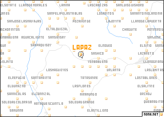
La Paz (Jalapa, Guatemala)La Paz is a town in the Jalapa region of Guatemala. An overview map of the region around La Paz is displayed below.
regional and 3d topo map of La Paz, Guatemala ::
La Paz airports ::
The nearest airport is GUA - Guatemala City La Aurora, located 44.6 km west of La Paz.
Other airports nearby include CBV - Coban (97.6 km north), SAL - San Salvador El Salvador Intl (174.7 km south east), Nearby towns ::
El Durazno (1.9km south) //
El Duraznito (1.9km south) //
Palo Verde (1.9km north) //
Sanyuyo (2.6km south west) //
San Francisco Poza Verde (2.6km south west) //
Sansurutate (2.6km south east) //
Los Izotes (2.6km north west) //
Sashico (3.6km east) //
Yerbabuena (4.0km south east) //
Carrizal (5.0km north) //
Fuentes de la Montaña (5.7km east) //
El Rodeo (5.7km east) //
Tatasirire (5.8km south) //
Los Llanitos (6.5km south east) //
Las Flores (6.5km south west) //
Los Magueyes (6.5km south west) //
Los Talpetates (6.5km north west) //
Sansirisay (6.5km north west) //
Las Flores (7.4km south) //
Poza Verde (7.4km north) //
Pino Gordo (7.2km east) //
El Paraíso (7.4km east) //
El Divisadero (7.4km east) //
El Talquezal (7.7km north west) //
El Aguacate (7.7km south west) //
Urlanta (8.1km south east) //
Montepeque (10.3km north west) //
La Joyita (10.3km north east) //
Agua Caliente (10.3km north east) //
[all distances 'as the bird flies' and approximate]  Places with similar names to La Paz, Guatemala ::
Disclaimer :: Information on this page comes without warranty of any kind |
||
|
Where is La Paz? Elevation and coordinates ::
Latitude (lat): 14°38'0"N Longitude (lon): 90°7'0"W
Elevation (approx.): 1779m (map arrows pan, magnifying glasses zoom) |
||
|
Visiting La Paz? Hotel/Accommodation ::
Book a hotel in La Paz Travel Guide ::
Buy a travel guide for Guatemala rental cars ::
car rental offers GPS waypoint ::
download a GPX waypoint (PoI) of La Paz for your GPS receiver
|
||