|
search place name
|
||
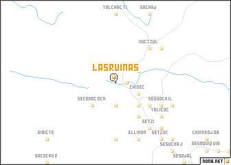
Las Ruinas (Alta Verapaz, Guatemala)Las Ruinas is a town in the Alta Verapaz region of Guatemala. An overview map of the region around Las Ruinas is displayed below.
regional and 3d topo map of Las Ruinas, Guatemala ::
Las Ruinas airports ::
The nearest airport is CBV - Coban, located 41.5 km south of Las Ruinas.
Other airports nearby include GUA - Guatemala City La Aurora (140.2 km south), Nearby towns ::
Chaquiquiché (1.8km east) //
Pecajbá (3.7km south) //
Chisec (4.0km south east) //
Canrujá (4.0km north east) //
Secomococh (5.1km south west) //
Malagueta (5.1km south east) //
Chaquirojá (6.5km south east) //
Secomontul (6.6km south east) //
Xuctzul (7.7km north east) //
Seguachil (8.0km south east) //
Setzí (9.1km south east) //
Yalicoc (9.0km south east) //
Arcopec (9.0km north east) //
Sarraxquén (10.3km south east) //
[all distances 'as the bird flies' and approximate] 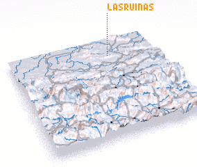 Places with similar names to Las Ruinas, Guatemala ::
// Los Serranos (US)
// Las Arenas (PA)
// Las Arenas (CU)
// Las Arenas (ES)
// Las Arenas (ES)
// Los Serranos (ES)
// Luciernas (ES)
// Las Arañas (CL)
// Las Arenas (CO)
// Las Arenas (GT)
Disclaimer :: Information on this page comes without warranty of any kind |
||
|
Where is Las Ruinas? Elevation and coordinates ::
Latitude (lat): 15°50'0"N Longitude (lon): 90°19'0"W
Elevation (approx.): 205m (map arrows pan, magnifying glasses zoom) |
||
|
Visiting Las Ruinas? Hotel/Accommodation ::
Book a hotel in Las Ruinas Travel Guide ::
Buy a travel guide for Guatemala rental cars ::
car rental offers GPS waypoint ::
download a GPX waypoint (PoI) of Las Ruinas for your GPS receiver
|
||