|
search place name
|
||
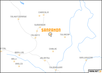
San Ramón (Huehuetenango, Guatemala)San Ramón is a town in the Huehuetenango region of Guatemala. An overview map of the region around San Ramón is displayed below.
regional and 3d topo map of San Ramón, Guatemala ::
San Ramón airports ::
The nearest airport is CBV - Coban, located 96.7 km south east of San Ramón.
Other airports nearby include GUA - Guatemala City La Aurora (159.7 km south east), TAP - Tapachula Intl (171.8 km south west), TGZ - Tuxtla Gutierrez Angel Albino Corzo (208.8 km west), Nearby towns ::
Yulmacap (4.9km east) //
Ojo de Agua (5.2km north west) //
Chiblac (5.5km south) //
Chiblac Buena Vista (5.4km north west) //
Yolhuitz (5.5km west) //
Chancolín (8.4km north) //
Ulutelac (8.7km north west) //
Jolomtaj (9.0km south) //
[all distances 'as the bird flies' and approximate] 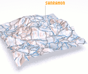 Places with similar names to San Ramón, Guatemala ::
// San Roman (BZ)
// San Roman (BZ)
// San Ramon (US)
// San Ramón (PA)
// San Romano (IT)
// San Romano (IT)
// San Ramón (CU)
// San Ramón (CU)
// San Ramón (CU)
// San Ramón (CU)
Disclaimer :: Information on this page comes without warranty of any kind |
||
|
Where is San Ramón? Elevation and coordinates ::
Latitude (lat): 15°51'53"N Longitude (lon): 91°12'40"W
Elevation (approx.): 670m (map arrows pan, magnifying glasses zoom) |
||
|
Visiting San Ramón? Hotel/Accommodation ::
Book a hotel in San Ramón Travel Guide ::
Buy a travel guide for Guatemala rental cars ::
car rental offers GPS waypoint ::
download a GPX waypoint (PoI) of San Ramón for your GPS receiver
|
||