|
search place name
|
||
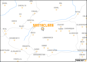
Santa Clara (Quiché, Guatemala)Santa Clara is a town in the Quiché region of Guatemala. An overview map of the region around Santa Clara is displayed below.
regional and 3d topo map of Santa Clara, Guatemala ::
Santa Clara airports ::
The nearest airport is CBV - Coban, located 63.9 km east of Santa Clara.
Other airports nearby include GUA - Guatemala City La Aurora (105.3 km south east), TAP - Tapachula Intl (162.6 km south west), SAL - San Salvador El Salvador Intl (302.9 km south east), Nearby towns ::
Joya Las Tablas (4.0km north west) //
La Barranca (4.1km south east) //
San Juan Cotzal (4.1km north west) //
Asich (4.6km west) //
Chisis (5.4km east) //
Xeputul (6.5km north west) //
Xobor (7.2km south) //
Tubán (7.1km east) //
Cajixay (7.4km east) //
Chimanzana (7.6km south) //
Chajul (8.5km north west) //
Cunén (9.3km south) //
Paguayil (10.3km south west) //
[all distances 'as the bird flies' and approximate] 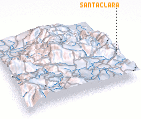 Places with similar names to Santa Clara, Guatemala ::
// Santa Clara (BR)
// Santa Clara (BR)
// Santa Clara (BR)
// Santa Clara (BR)
// Santa Clara (BR)
// Santa Clara (BR)
// Santa Clara (BR)
// Santa Clara (BR)
// Santa Clara (BR)
// Santa Clara (BR)
Disclaimer :: Information on this page comes without warranty of any kind |
||
|
Where is Santa Clara? Elevation and coordinates ::
Latitude (lat): 15°25'0"N Longitude (lon): 91°0'0"W
Elevation (approx.): 2179m (map arrows pan, magnifying glasses zoom) |
||
|
Visiting Santa Clara? Hotel/Accommodation ::
Book a hotel in Santa Clara Travel Guide ::
Buy a travel guide for Guatemala rental cars ::
car rental offers GPS waypoint ::
download a GPX waypoint (PoI) of Santa Clara for your GPS receiver
|
||