|
search place name
|
||
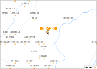
Bānspāni (Orissa, India)Bānspāni is a town in the Orissa region of India. An overview map of the region around Bānspāni is displayed below.
regional and 3d topo map of Bānspāni, India ::
Bānspāni airports ::
The nearest airport is RRK - Rourkela, located 70.7 km north west of Bānspāni.
Other airports nearby include IXW - Jamshedpur (119.1 km north east), IXR - Ranchi Birsa Munda (147.8 km north), BBI - Bhubaneswar Bhubaneshwar (196.6 km south), DBO - Dhanbad (228.8 km north east), Nearby towns ::
Joruri (4.1km south west) //
Kūrband (5.1km south west) //
Joribār (5.8km south) //
Kundrupāni (7.1km west) //
Roida (7.6km north west) //
Gurda (9.0km south west) //
Jhārgaon (9.0km north west) //
Chamakpur (8.8km north east) //
Gonua (10.1km south west) //
[all distances 'as the bird flies' and approximate]  Places with similar names to Bānspāni, India ::
// Ban Sapan (TH)
// Ban Sap Noi (TH)
// Ban Sap Phun (TH)
// Ban Sop O Nai (TH)
// Ban Sop Pan (TH)
// Ban Sop Pon (TH)
// Ban Sop Puen (TH)
// Ban Sop Un (TH)
// Ban Sapèn (LA)
// Ban Sapouan (LA)
Disclaimer :: Information on this page comes without warranty of any kind |
||
|
Where is Bānspāni? Elevation and coordinates ::
Latitude (lat): 21°59'0"N Longitude (lon): 85°26'0"E
Elevation (approx.): 539m (map arrows pan, magnifying glasses zoom) |
||
|
Visiting Bānspāni? Hotel/Accommodation ::
Book a hotel in Bānspāni Travel Guide ::
Buy a travel guide for India rental cars ::
car rental offers GPS waypoint ::
download a GPX waypoint (PoI) of Bānspāni for your GPS receiver
|
||