|
search place name
|
||
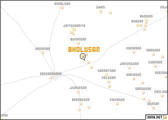
Bholusar (Rājasthān, India)Bholusar is a town in the Rājasthān region of India. An overview map of the region around Bholusar is displayed below.
regional and 3d topo map of Bholusar, India ::
Bholusar airports ::
The nearest airport is JAI - Jaipur, located 220.8 km south east of Bholusar.
Nearby towns ::
Bebra (1.0km south east) //
Bhimsar (1.4km north) //
Ursar (2.1km south east) //
Ponsisar (2.6km north) //
Bukansar (3.9km north) //
Harpatsar (5.6km south east) //
Gajusar (6.2km north) //
Thariyāsar (6.7km north) //
Jaitsiīsariya (7.0km north) //
Jiundesar (7.2km south) //
Jaetasar (7.2km north) //
Kālusar (6.9km south east) //
Pūlāsar (7.6km south east) //
Sardārshahr (7.6km south west) //
[all distances 'as the bird flies' and approximate] 
Disclaimer :: Information on this page comes without warranty of any kind |
||
|
Where is Bholusar? Elevation and coordinates ::
Latitude (lat): 28°28'8"N Longitude (lon): 74°32'59"E
Elevation (approx.): 252m (map arrows pan, magnifying glasses zoom) |
||
|
Visiting Bholusar? Hotel/Accommodation ::
Book a hotel in Bholusar Travel Guide ::
Buy a travel guide for India rental cars ::
car rental offers GPS waypoint ::
download a GPX waypoint (PoI) of Bholusar for your GPS receiver
|
||