|
search place name
|
||
Chhatrahāma (Jammu and Kashmīr, India)Chhatrahāma is a town in the Jammu and Kashmīr region of India. An overview map of the region around Chhatrahāma is displayed below.
regional and 3d topo map of Chhatrahāma, India ::

Chhatrahāma airports ::
The nearest airport is SXR - Srinagar, located 23.6 km south of Chhatrahāma.
Other airports nearby include RAZ - Rawala Kot Rawalakot (105.9 km west), MFG - Muzaffarabad (126.8 km west), IXJ - Jammu (165.8 km south), ISB - Islamabad Chaklala (175.6 km west), Nearby towns ::
Khamar (1.2km north west) //
Yehal (1.5km south east) //
Inderhāma (1.7km south west) //
Mulphak (1.8km south) //
Burzahom (1.8km south) //
Hodūra (1.8km west) //
Dhaniahāma (2.0km south east) //
Gorsu (2.0km south west) //
Burzāhāma (2.1km south east) //
Telbal (2.4km south) //
Patha Ārampura (2.1km west) //
Takia Sangrish (2.6km north) //
Saidpur (2.4km south east) //
Batpur (2.9km south west) //
Batāpura (2.8km south west) //
Darabāgh (3.0km south east) //
Pāzwālpura (3.3km south) //
Bāgh Chandpura (3.2km south east) //
Saidapor Hamchi (3.0km west) //
Ziārat (3.0km east) //
Bākra (3.0km west) //
Harwan (3.2km south east) //
Mūtbāgh (3.3km south east) //
Diginibal (3.6km north west) //
Bānigām (4.0km south) //
Dāra (3.4km east) //
Wārapāhu (3.5km west) //
Murinderbāgh (3.6km east) //
Nu Chid (3.7km south east) //
[all distances 'as the bird flies' and approximate] 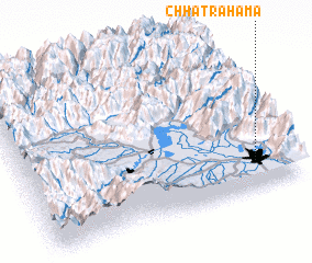 Places with similar names to Chhatrahāma, India :: Disclaimer :: Information on this page comes without warranty of any kind |
||
|
Where is Chhatrahāma? Elevation and coordinates ::
Latitude (lat): 34°11'0"N Longitude (lon): 74°52'20"E
Elevation (approx.): 1660m (map arrows pan, magnifying glasses zoom) |
||
|
Visiting Chhatrahāma? Hotel/Accommodation ::
Book a hotel in Chhatrahāma Travel Guide ::
Buy a travel guide for India rental cars ::
car rental offers GPS waypoint ::
download a GPX waypoint (PoI) of Chhatrahāma for your GPS receiver
|
||