|
search place name
|
||
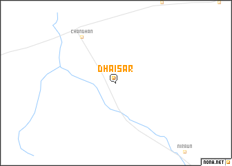
Dhaisar (Rājasthān, India)Dhaisar is a town in the Rājasthān region of India. An overview map of the region around Dhaisar is displayed below.
regional and 3d topo map of Dhaisar, India ::
Dhaisar airports ::
The nearest airport is JSA - Jaisalmer, located 49.9 km west of Dhaisar.
Other airports nearby include JOH - Jodhpur (183.1 km south east), RYK - Rahim Yar Khan Sheikh Zayed (194.8 km north west), Nearby towns ::
Chandhan (8.9km north west) //
[all distances 'as the bird flies' and approximate]  Places with similar names to Dhaisar, India ::
// Deh Aşghar (IR)
// Deh-e Aşghar (IR)
// Deh-e Aşghar (IR)
// Dahasri (BD)
// Dhusar (BD)
// Dhusaria (BD)
// Dhusera (IN)
// Dohāzāri (BD)
// Tuohisaari (FI)
// Dhī Şūrah (YE)
Disclaimer :: Information on this page comes without warranty of any kind |
||
|
Where is Dhaisar? Elevation and coordinates ::
Latitude (lat): 26°55'0"N Longitude (lon): 71°22'0"E
Elevation (approx.): 220m (map arrows pan, magnifying glasses zoom) |
||
|
Visiting Dhaisar? Hotel/Accommodation ::
Book a hotel in Dhaisar Travel Guide ::
Buy a travel guide for India rental cars ::
car rental offers GPS waypoint ::
download a GPX waypoint (PoI) of Dhaisar for your GPS receiver
|
||