|
search place name
|
||
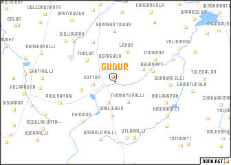
Gūdūr (Andhra Pradesh, India)Gūdūr is a town in the Andhra Pradesh region of India. An overview map of the region around Gūdūr is displayed below.
regional and 3d topo map of Gūdūr, India ::
Gūdūr airports ::
The nearest airport is HYD - Hyderabad, located 39.6 km north of Gūdūr.
Other airports nearby include BEP - Bellary (275.1 km south west), Nearby towns ::
Beraguda (3.2km north) //
Kandukur (3.5km south) //
Kottur (3.4km west) //
Thimmāyapalli (3.7km south east) //
Rāchlūr (4.8km north east) //
Dabliguda (5.3km south) //
Lemūr (5.3km north) //
Tulsinagar (5.4km west) //
Tumlur (5.7km north west) //
Begampet (6.1km east) //
Timmāpur (7.2km north east) //
Mohbatnagar (7.4km north west) //
Nendnūr (8.1km south west) //
Saraswatiguda (8.3km north) //
Maisaram (8.2km north west) //
Mailāwaram (8.5km east) //
Gumadavelli (8.5km east) //
Siglipuram (9.4km north west) //
Mīr Khānpet (9.7km south east) //
Gangaram (10.3km north west) //
Kurumidda (10.6km south east) //
[all distances 'as the bird flies' and approximate] 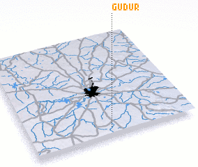 Places with similar names to Gūdūr, India ::
Disclaimer :: Information on this page comes without warranty of any kind |
||
|
Where is Gūdūr? Elevation and coordinates ::
Latitude (lat): 17°5'47"N Longitude (lon): 78°30'0"E
Elevation (approx.): 616m (map arrows pan, magnifying glasses zoom) |
||
|
Visiting Gūdūr? Hotel/Accommodation ::
Book a hotel in Gūdūr Travel Guide ::
Buy a travel guide for India rental cars ::
car rental offers GPS waypoint ::
download a GPX waypoint (PoI) of Gūdūr for your GPS receiver
|
||