|
search place name
|
||
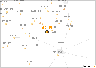
Jāleu (Rājasthān, India)Jāleu is a town in the Rājasthān region of India. An overview map of the region around Jāleu is displayed below.
regional and 3d topo map of Jāleu, India ::
Jāleu airports ::
The nearest airport is JAI - Jaipur, located 162.9 km south east of Jāleu.
Other airports nearby include JOH - Jodhpur (272.5 km south west), Nearby towns ::
Phadanpura (2.2km north east) //
Gorās (2.3km north west) //
Dewās (2.5km east) //
Dānrunda (2.9km north west) //
Dhāni (4.3km north west) //
Nagardās (5.2km north west) //
Odesar (5.5km north east) //
Sabsar (5.4km south west) //
Chota Goria (5.8km east) //
Nāri (6.4km south west) //
Dhāni Baroa (6.8km north) //
Khono (6.8km north east) //
Rol (6.4km west) //
Dhāndhāni (6.7km north west) //
Fatehpur (6.8km south east) //
Bōgās (6.9km north west) //
Khāreta (7.9km north) //
Gangāpurio (8.4km north) //
Hetamsir (7.6km east) //
Barā Gorra (7.8km east) //
Fatehpur (8.9km south east) //
Jugulpura (8.9km north west) //
Rasulpur (8.8km north east) //
Naharsir (9.1km north east) //
[all distances 'as the bird flies' and approximate]  Places with similar names to Jāleu, India ::
Disclaimer :: Information on this page comes without warranty of any kind |
||
|
Where is Jāleu? Elevation and coordinates ::
Latitude (lat): 28°3'26"N Longitude (lon): 74°54'53"E
Elevation (approx.): 315m (map arrows pan, magnifying glasses zoom) |
||
|
Visiting Jāleu? Hotel/Accommodation ::
Book a hotel in Jāleu Travel Guide ::
Buy a travel guide for India rental cars ::
car rental offers GPS waypoint ::
download a GPX waypoint (PoI) of Jāleu for your GPS receiver
|
||