|
search place name
|
||
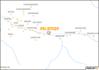
Malangām (Jammu and Kashmīr, India)Malangām is a town in the Jammu and Kashmīr region of India. An overview map of the region around Malangām is displayed below.
regional and 3d topo map of Malangām, India ::
Malangām airports ::
The nearest airport is SXR - Srinagar, located 69.6 km south west of Malangām.
Other airports nearby include RAZ - Rawala Kot Rawalakot (145.7 km south west), MFG - Muzaffarabad (152.1 km west), GIL - Gilgit (170.6 km north west), IXJ - Jammu (206.6 km south), Nearby towns ::
Hasangām (1.8km west) //
Badoāb (2.6km north east) //
Gundi Gul Shekh (3.1km west) //
Angaikor (3.5km east) //
Būglandar (3.9km west) //
Kunpathri (4.7km south west) //
Khutian Thal (4.8km west) //
Dalimond (5.5km north west) //
Dangidār (5.4km east) //
Tatri Thal (5.7km west) //
Sarodāb (6.4km west) //
Lor Khānba (6.4km east) //
Maranu (8.1km north west) //
Sārīmaidān (9.0km north west) //
[all distances 'as the bird flies' and approximate] 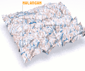 Places with similar names to Malangām, India ::
// Malingumu (CD)
// Mbilankamba II (CD)
// Maulinguem (IN)
// Malangama (LK)
// Malangama (LK)
// Malingmiao (CN)
// Malinkam (CM)
Disclaimer :: Information on this page comes without warranty of any kind |
||
|
Where is Malangām? Elevation and coordinates ::
Latitude (lat): 34°32'0"N Longitude (lon): 75°8'50"E
Elevation (approx.): 2854m (map arrows pan, magnifying glasses zoom) |
||
|
Visiting Malangām? Hotel/Accommodation ::
Book a hotel in Malangām Travel Guide ::
Buy a travel guide for India rental cars ::
car rental offers GPS waypoint ::
download a GPX waypoint (PoI) of Malangām for your GPS receiver
|
||