|
search place name
|
||
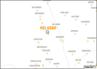
Melusar (Rājasthān, India)Melusar is a town in the Rājasthān region of India. An overview map of the region around Melusar is displayed below.
regional and 3d topo map of Melusar, India ::
Melusar airports ::
The nearest airport is JAI - Jaipur, located 198.4 km south east of Melusar.
Other airports nearby include JOH - Jodhpur (263.7 km south west), Nearby towns ::
Pābuji Mahārāj Ka Dhora (3.1km north east) //
Mālāsar (4.0km north east) //
Chhotrio (4.5km south west) //
Gogāsar (4.6km south east) //
Khileriyan (5.0km north west) //
Chainpura (5.5km south east) //
Hainsasar (6.3km south) //
Anandwāsi (6.7km north west) //
Golsar (7.4km south) //
Mangāsar (7.7km north) //
Asalsar (9.3km north east) //
[all distances 'as the bird flies' and approximate]  Places with similar names to Melusar, India ::
// Malseira (PT)
// Molí Azor (ES)
// Maloozero (RU)
// Malyye Izori (RU)
// Malyye Syry (RU)
// Mālāsar (IN)
// Malisar (IN)
// Mālsari (IN)
// Maulāsar (IN)
// Melusar (IN)
Disclaimer :: Information on this page comes without warranty of any kind |
||
|
Where is Melusar? Elevation and coordinates ::
Latitude (lat): 28°13'0"N Longitude (lon): 74°33'0"E
Elevation (approx.): 296m (map arrows pan, magnifying glasses zoom) |
||
|
Visiting Melusar? Hotel/Accommodation ::
Book a hotel in Melusar Travel Guide ::
Buy a travel guide for India rental cars ::
car rental offers GPS waypoint ::
download a GPX waypoint (PoI) of Melusar for your GPS receiver
|
||