|
search place name
|
||
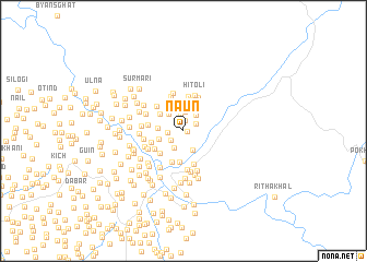
Nāun (Himāchal Pradesh, India)Nāun is a town in the Himāchal Pradesh region of India. An overview map of the region around Nāun is displayed below.
regional and 3d topo map of Nāun, India ::
Nāun airports ::
The nearest airport is DED - Dehra Dun Dehradun, located 59.0 km north west of Nāun.
Other airports nearby include PGH - Nainital Pantnagar (125.4 km south east), IXC - Chandigarh (203.0 km north west), DEL - Delhi Indira Gandhi Intl (221.3 km south west), KUU - Kulu Kullu Manali (260.5 km north west), Nearby towns ::
Sīraun (0.4km east) //
Kandāra (1.0km north) //
Chāmi (1.4km north east) //
Manjgaon (1.4km west) //
Hairākholi (1.5km south west) //
Khugsa (1.7km north) //
Kingori (1.9km north) //
Kurīgaon (2.0km south west) //
Balūnīgaon (2.0km north east) //
Kānda (2.1km south) //
Silun (2.1km north) //
Layera (2.3km north) //
Mahār (2.2km north west) //
Tīr (2.5km north) //
Ameh (2.3km west) //
Betpāni (2.4km west) //
Bakroli (2.8km north) //
Bedulgaon (2.7km north west) //
Bheti (3.0km north) //
Dhaulidhār (3.2km south) //
Raur (3.2km north) //
Batkholu (3.1km south west) //
Rautela (3.3km south) //
Silangaon (3.0km south west) //
Dānda (3.2km south west) //
Borikh (3.5km north) //
Dharigaon (3.5km south) //
Bānghāt (3.2km west) //
Dhaura (3.5km north west) //
[all distances 'as the bird flies' and approximate]  Places with similar names to Nāun, India ::
Disclaimer :: Information on this page comes without warranty of any kind |
||
|
Where is Nāun? Elevation and coordinates ::
Latitude (lat): 29°57'39"N Longitude (lon): 78°43'58"E
Elevation (approx.): 1198m (map arrows pan, magnifying glasses zoom) |
||
|
Visiting Nāun? Hotel/Accommodation ::
Book a hotel in Nāun Travel Guide ::
Buy a travel guide for India rental cars ::
car rental offers GPS waypoint ::
download a GPX waypoint (PoI) of Nāun for your GPS receiver
|
||