|
search place name
|
||
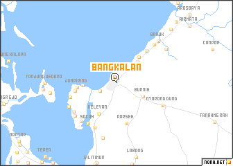
Bangkalan (Jawa Timur, Indonesia)Bangkalan is a town in the Jawa Timur region of Indonesia. An overview map of the region around Bangkalan is displayed below.
regional and 3d topo map of Bangkalan, Indonesia ::
Nearby towns ::
Mertajasa (2.9km south west) //
Bancaran (3.2km north east) //
Burnih (4.8km south east) //
Sebaneh (4.8km north east) //
Jungpiring Timur (5.4km west) //
Sabiyan (5.5km north east) //
Keleyan (5.7km south west) //
Jumpiring (6.4km west) //
Parseh (6.7km south) //
Jungpiring Barat (6.7km west) //
Gebang (7.1km north east) //
Sembilangan (7.7km west) //
Socah (7.9km south west) //
Pedeng (8.0km south west) //
Nyorongdung (8.2km south east) //
Buluhbarat (8.2km south west) //
Junganyar (8.3km south west) //
Dakiring (8.5km south west) //
Slempit (8.5km south west) //
Pocogan (8.6km north east) //
Baruk (9.6km north east) //
Umbul (9.7km north east) //
Lancang (12.2km north east) //
[all distances 'as the bird flies' and approximate]  Places with similar names to Bangkalan, Indonesia ::
// Bungkalan (PH)
// Bangkalaan (ID)
// Bengkalan (ID)
// Bungkulan (ID)
// Bongcalon (PH)
// Bani Koklénou (CI)
Disclaimer :: Information on this page comes without warranty of any kind |
||
|
Where is Bangkalan? Elevation and coordinates ::
Latitude (lat): 7°1'57"S Longitude (lon): 112°44'40"E
Elevation (approx.): 5m (map arrows pan, magnifying glasses zoom) |
||
|
Visiting Bangkalan? Hotel/Accommodation ::
Book a hotel in Bangkalan Travel Guide ::
Buy a travel guide for Indonesia rental cars ::
car rental offers GPS waypoint ::
download a GPX waypoint (PoI) of Bangkalan for your GPS receiver
|
||