|
search place name
|
||
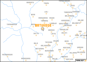
Batukede (Sulawesi Selatan, Indonesia)Batukede is a town in the Sulawesi Selatan region of Indonesia. An overview map of the region around Batukede is displayed below.
regional and 3d topo map of Batukede, Indonesia ::
Batukede airports ::
The nearest airport is UPG - Ujung Pandang Hasanuddin, located 196.2 km south of Batukede.
Other airports nearby include PSJ - Poso Kasiguncu (230.4 km north east), Nearby towns ::
Buntudea (2.3km north east) //
Tombang (3.5km north) //
Baroko (3.5km east) //
Datte (3.7km south west) //
Laiya (4.7km south east) //
Bege (4.8km north west) //
Ponggamisi (4.8km north) //
Lumbaja (4.8km north east) //
Redak (6.0km north east) //
Tocemba (6.2km south) //
Bulo (6.9km south west) //
Malimongan (7.3km south) //
Kalosi (7.5km south east) //
Lali (7.6km north) //
Bena (7.6km north west) //
Bolang (8.3km south east) //
Baturape (8.7km south) //
Sangtempe (9.0km east) //
Bule (11.9km south east) //
[all distances 'as the bird flies' and approximate] 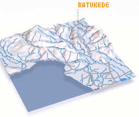 Places with similar names to Batukede, Indonesia ::
Disclaimer :: Information on this page comes without warranty of any kind |
||
|
Where is Batukede? Elevation and coordinates ::
Latitude (lat): 3°18'2"S Longitude (lon): 119°46'21"E
Elevation (approx.): 1351m (map arrows pan, magnifying glasses zoom) |
||
|
Visiting Batukede? Hotel/Accommodation ::
Book a hotel in Batukede Travel Guide ::
Buy a travel guide for Indonesia rental cars ::
car rental offers GPS waypoint ::
download a GPX waypoint (PoI) of Batukede for your GPS receiver
|
||