|
search place name
|
||
Bontobatu (Indonesia)Bontobatu is a town in Indonesia. An overview map of the region around Bontobatu is displayed below.
regional and 3d topo map of Bontobatu, Indonesia ::

Bontobatu airports ::
The nearest airport is UPG - Ujung Pandang Hasanuddin, located 187.4 km south of Bontobatu.
Other airports nearby include PSJ - Poso Kasiguncu (249.3 km north east), Nearby towns ::
Poko (1.9km south) //
Dara (3.1km west) //
Talangrambu (4.7km north east) //
Rampusa (4.8km south) //
Siamang (5.6km north) //
Kadundung (5.9km south) //
Bone (6.7km south east) //
Rajangballa (9.8km south west) //
[all distances 'as the bird flies' and approximate] 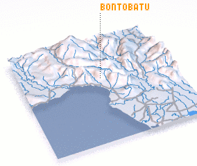 Places with similar names to Bontobatu, Indonesia ::
// Ban Ta Bat (TH)
// Ban Tab Tao (TH)
// Binodbaid (BD)
// Binodebāti (BD)
// Bontobaddo (ID)
// Bāndi Bata (PK)
// Bandouboto (GN)
// Boundoubadi (ML)
// Bontobotoa (ID)
// Bandābād (AF)
Disclaimer :: Information on this page comes without warranty of any kind |
||
|
Where is Bontobatu? Elevation and coordinates ::
Latitude (lat): 3°22'0"S Longitude (lon): 119°32'0"E
Elevation (approx.): 684m (map arrows pan, magnifying glasses zoom) |
||
|
Visiting Bontobatu? Hotel/Accommodation ::
Book a hotel in Bontobatu Travel Guide ::
Buy a travel guide for Indonesia rental cars ::
car rental offers GPS waypoint ::
download a GPX waypoint (PoI) of Bontobatu for your GPS receiver
|
||