|
search place name
|
||
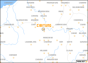
Cibitung (Indonesia)Cibitung is a town in Indonesia. An overview map of the region around Cibitung is displayed below.
regional and 3d topo map of Cibitung, Indonesia ::
Cibitung airports ::
The nearest airport is CGK - Jakarta Soekarno Hatta Intl, located 101.3 km north east of Cibitung.
Nearby towns ::
Munjul (0.0km north) //
Cigintung (3.7km south) //
Cijolang (4.1km south west) //
Panacaran (4.1km south east) //
Cikayas (4.1km north west) //
Bojongkoneng (4.1km north west) //
Dukuh (4.1km north east) //
Angsana (5.2km north west) //
Weluku (5.6km north) //
Cisempur (5.9km south) //
Ciranggon (6.7km south east) //
Cibarat (6.7km south east) //
Cipining (6.7km north west) //
Bojongmanik (7.4km north) //
Lebakkeusik (7.6km east) //
Leuwibalang (7.8km south west) //
Kopi (9.2km south east) //
Pakis (10.4km north east) //
[all distances 'as the bird flies' and approximate] 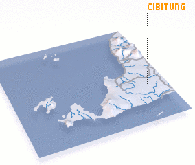 Places with similar names to Cibitung, Indonesia ::
// Subbotinka (RU)
// Subbotniki (RU)
// Subbotniki (RU)
// Subbotniki (RU)
// Subbotniki (RU)
// Subbotniki (RU)
// Sabudaung (MM)
// Sebatong (MY)
// Sabatenga (BF)
// Sabtenga (BF)
Disclaimer :: Information on this page comes without warranty of any kind |
||
|
Where is Cibitung? Elevation and coordinates ::
Latitude (lat): 6°37'0"S Longitude (lon): 105°53'0"E
Elevation (approx.): 16m (map arrows pan, magnifying glasses zoom) |
||
|
Visiting Cibitung? Hotel/Accommodation ::
Book a hotel in Cibitung Travel Guide ::
Buy a travel guide for Indonesia rental cars ::
car rental offers GPS waypoint ::
download a GPX waypoint (PoI) of Cibitung for your GPS receiver
|
||