|
search place name
|
||
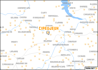
Cipeujeuh (Indonesia)Cipeujeuh is a town in Indonesia. An overview map of the region around Cipeujeuh is displayed below.
regional and 3d topo map of Cipeujeuh, Indonesia ::
Cipeujeuh airports ::
The nearest airport is CGK - Jakarta Soekarno Hatta Intl, located 92.7 km north west of Cipeujeuh.
Nearby towns ::
Nangka (0.6km east) //
Bakom (1.9km south west) //
Kepuh 1 (2.4km north) //
Cinangsi (2.6km west) //
Kamurang (2.6km north east) //
Bojong 1 (3.4km south) //
Cidamar (3.6km south east) //
Cikidang Satu (3.9km south east) //
Kademangan (4.1km south west) //
Wikoje (4.2km east) //
Pasirempui (4.7km east) //
Cijambu (5.4km north east) //
Bayabang (5.5km east) //
Cibakom (5.8km west) //
Tarikolot (5.8km west) //
Ciramaeuwah-girang (5.9km north) //
Citalang (5.9km south west) //
Cinswala 1 (6.0km west) //
Bobojong (6.0km south west) //
Ciandam 1 (6.3km west) //
Naringgul (6.4km north) //
Ciandam 2 (6.6km south west) //
Sindangraja Dua (6.6km south east) //
Sukasrana (6.7km south west) //
Nyangkakat (6.7km north west) //
Cidahu (6.7km north east) //
Warungdanas (6.7km south west) //
Rawaselang (7.3km south east) //
Cirawa (7.4km east) //
[all distances 'as the bird flies' and approximate]  Places with similar names to Cipeujeuh, Indonesia ::
Disclaimer :: Information on this page comes without warranty of any kind |
||
|
Where is Cipeujeuh? Elevation and coordinates ::
Latitude (lat): 6°44'0"S Longitude (lon): 107°14'0"E
Elevation (approx.): 330m (map arrows pan, magnifying glasses zoom) |
||
|
Visiting Cipeujeuh? Hotel/Accommodation ::
Book a hotel in Cipeujeuh Travel Guide ::
Buy a travel guide for Indonesia rental cars ::
car rental offers GPS waypoint ::
download a GPX waypoint (PoI) of Cipeujeuh for your GPS receiver
|
||