|
search place name
|
||
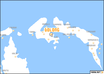
Dolong (Sulawesi Tengah, Indonesia)Dolong is a town in the Sulawesi Tengah region of Indonesia. An overview map of the region around Dolong is displayed below.
regional and 3d topo map of Dolong, Indonesia ::
Dolong airports ::
The nearest airport is LUW - Luwuk Bubung, located 105.7 km south east of Dolong.
Other airports nearby include GTO - Gorontalo Jalaluddin (122.1 km north east), PSJ - Poso Kasiguncu (215.2 km south west), Nearby towns ::
Tutung (1.6km south west) //
Loe (1.9km south east) //
Olilian (3.2km west) //
Lempek (3.8km north west) //
Tumpang (4.0km north east) //
Popolii (4.1km north west) //
Salinggoha (6.2km east) //
Nanasi (6.6km north east) //
Toani (7.0km west) //
Malapo (7.9km east) //
[all distances 'as the bird flies' and approximate] 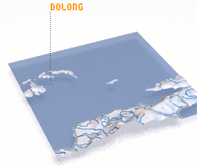 Places with similar names to Dolong, Indonesia ::
Disclaimer :: Information on this page comes without warranty of any kind |
||
|
Where is Dolong? Elevation and coordinates ::
Latitude (lat): 0°15'51"S Longitude (lon): 122°12'56"E
Elevation (approx.): 49m (map arrows pan, magnifying glasses zoom) |
||
|
Visiting Dolong? Hotel/Accommodation ::
Book a hotel in Dolong Travel Guide ::
Buy a travel guide for Indonesia rental cars ::
car rental offers GPS waypoint ::
download a GPX waypoint (PoI) of Dolong for your GPS receiver
|
||