|
search place name
|
||
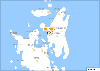
Dumar (Maluku, Indonesia)Dumar is a town in the Maluku region of Indonesia. An overview map of the region around Dumar is displayed below.
regional and 3d topo map of Dumar, Indonesia ::
Dumar airports ::
The nearest airport is KNG - Kaimana, located 242.1 km north east of Dumar.
Nearby towns ::
Mangon (0.7km north east) //
Watraan (2.6km east) //
Lobi (3.8km north) //
Watdek (4.0km south) //
Litman (4.5km west) //
Ohoitahait (4.7km east) //
Taar (5.2km south) //
Ngadi (5.3km north) //
Dula (5.3km north) //
Ohitel (5.4km east) //
Tual (5.9km south) //
Koiseer (6.0km south west) //
Langgur (6.5km south west) //
Dudumahan (7.2km west) //
Faan (7.8km south) //
Ohoideer (7.9km west) //
Gelanit (8.0km south west) //
Naamlong (8.0km south west) //
Tawinohoi (8.4km north) //
Lebetau (8.7km north) //
Letman (8.7km west) //
Defur (9.2km north east) //
Naam (10.4km north east) //
[all distances 'as the bird flies' and approximate] 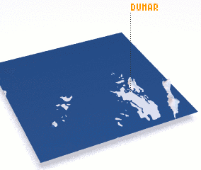 Places with similar names to Dumar, Indonesia ::
Disclaimer :: Information on this page comes without warranty of any kind |
||
|
Where is Dumar? Elevation and coordinates ::
Latitude (lat): 5°36'51"S Longitude (lon): 132°44'36"E
Elevation (approx.): 13m (map arrows pan, magnifying glasses zoom) |
||
|
Visiting Dumar? Hotel/Accommodation ::
Book a hotel in Dumar Travel Guide ::
Buy a travel guide for Indonesia rental cars ::
car rental offers GPS waypoint ::
download a GPX waypoint (PoI) of Dumar for your GPS receiver
|
||