|
search place name
|
||
Jetis (Indonesia)Jetis is a town in Indonesia. An overview map of the region around Jetis is displayed below.
regional and 3d topo map of Jetis, Indonesia ::
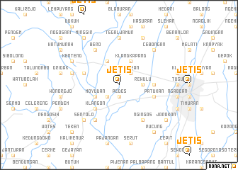
Nearby towns ::
Bletuk (1.9km north) //
Pedes (1.9km south) //
Godean (2.6km north east) //
Sedayu (2.6km south west) //
Rewulu (3.7km east) //
Klangkapang (4.1km north east) //
Ngijon (4.1km north west) //
Moyudan (4.1km south west) //
Klangon (5.2km south west) //
Gamping (5.5km east) //
Sejatisetran (5.8km west) //
Patukan (5.8km east) //
Ngingas (6.7km south east) //
Bero (6.7km north west) //
Bentangan (6.7km south west) //
Tegaljamur (7.4km north) //
Parakan (7.4km north) //
Nanggulan (7.6km west) //
Sentolo (7.8km south west) //
Cebongan (7.8km north east) //
Seyegan (8.3km north east) //
Kenteng (8.2km north west) //
Minggir (9.2km north west) //
Jarakan (9.2km south east) //
Pucung (9.2km south east) //
Teken (10.4km south west) //
[all distances 'as the bird flies' and approximate] 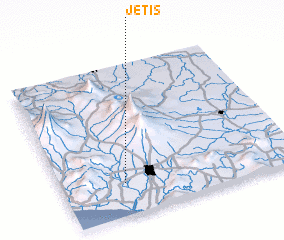 Places with similar names to Jetis, Indonesia ::
Disclaimer :: Information on this page comes without warranty of any kind |
||
|
Where is Jetis? Elevation and coordinates ::
Latitude (lat): 7°47'0"S Longitude (lon): 110°16'0"E
Elevation (approx.): 98m (map arrows pan, magnifying glasses zoom) |
||
|
Visiting Jetis? Hotel/Accommodation ::
Book a hotel in Jetis Travel Guide ::
Buy a travel guide for Indonesia rental cars ::
car rental offers GPS waypoint ::
download a GPX waypoint (PoI) of Jetis for your GPS receiver
|
||