|
search place name
|
||
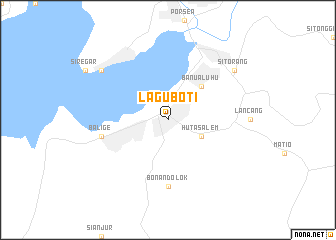
Laguboti (Indonesia)Laguboti is a town in Indonesia. An overview map of the region around Laguboti is displayed below.
regional and 3d topo map of Laguboti, Indonesia ::
Laguboti airports ::
The nearest airport is MES - Medan Polonia, located 143.1 km north of Laguboti.
Other airports nearby include GNS - Gunung Sitoli Binaka (205.9 km south west), Nearby towns ::
Hutasalem (4.1km south east) //
Banualuhu (5.2km north east) //
Bonandolok (7.4km south) //
Balige (7.6km west) //
Parmonangan (9.3km north west) //
Sitorang (9.3km north east) //
[all distances 'as the bird flies' and approximate] 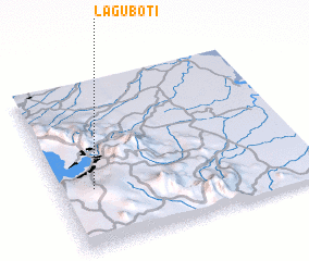 Places with similar names to Laguboti, Indonesia ::
// La Guabita (PA)
// La Guabita (PA)
// Legbąd (PL)
// Łękobudy (PL)
// La Cuabita (CU)
// La Cubita (CU)
// Logobate (ZA)
// Lugabuti (TP)
// Lokbatu (ID)
// Lakābād (IR)
Disclaimer :: Information on this page comes without warranty of any kind |
||
|
Where is Laguboti? Elevation and coordinates ::
Latitude (lat): 2°21'0"N Longitude (lon): 99°8'0"E
Elevation (approx.): 925m (map arrows pan, magnifying glasses zoom) |
||
|
Visiting Laguboti? Hotel/Accommodation ::
Book a hotel in Laguboti Travel Guide ::
Buy a travel guide for Indonesia rental cars ::
car rental offers GPS waypoint ::
download a GPX waypoint (PoI) of Laguboti for your GPS receiver
|
||