|
search place name
|
||
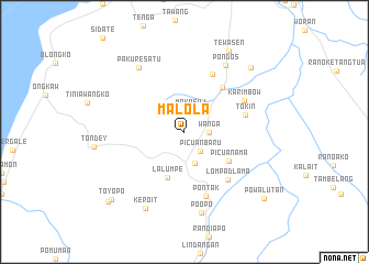
Malola (Sulawesi Utara, Indonesia)Malola is a town in the Sulawesi Utara region of Indonesia. An overview map of the region around Malola is displayed below.
regional and 3d topo map of Malola, Indonesia ::
Malola airports ::
The nearest airport is MDC - Manado Sam Ratulangi, located 73.5 km north east of Malola.
Other airports nearby include GTO - Gorontalo Jalaluddin (186.9 km west), Nearby towns ::
Makasili (2.3km north) //
Wanga (2.5km east) //
Picuan Baru (2.5km south east) //
Motoling (3.3km south) //
Lalumpe (4.9km south) //
Picuan Ama (5.4km south east) //
Wakan (5.9km north east) //
Tokin (6.5km east) //
Kumelembuai (6.5km north east) //
Lompad Lama (6.6km south east) //
Karimbow (6.9km north east) //
Pontak (6.9km south) //
Pondos (8.0km north east) //
Pakure Satu (8.0km north west) //
Poopo (8.4km south) //
Keroit (8.7km south west) //
Tewasen (9.4km north east) //
Elusan (9.4km north east) //
Toyopo (10.2km south west) //
Powalutan (10.5km south east) //
Toyopon (10.5km south west) //
[all distances 'as the bird flies' and approximate] 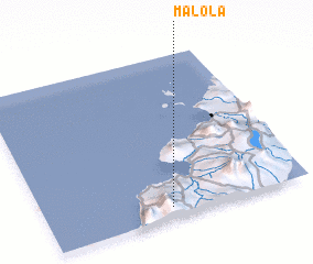 Places with similar names to Malola, Indonesia ::
Disclaimer :: Information on this page comes without warranty of any kind |
||
|
Where is Malola? Elevation and coordinates ::
Latitude (lat): 1°3'51"N Longitude (lon): 124°28'28"E
Elevation (approx.): 602m (map arrows pan, magnifying glasses zoom) |
||
|
Visiting Malola? Hotel/Accommodation ::
Book a hotel in Malola Travel Guide ::
Buy a travel guide for Indonesia rental cars ::
car rental offers GPS waypoint ::
download a GPX waypoint (PoI) of Malola for your GPS receiver
|
||