|
search place name
|
||
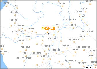
Masalo (Sulawesi Selatan, Indonesia)Masalo is a town in the Sulawesi Selatan region of Indonesia. An overview map of the region around Masalo is displayed below.
regional and 3d topo map of Masalo, Indonesia ::
Masalo airports ::
The nearest airport is UPG - Ujung Pandang Hasanuddin, located 150.9 km south of Masalo.
Nearby towns ::
Teppo (2.1km east) //
Lepangang (3.1km south west) //
Palirang (3.3km south east) //
Benteng Dua (3.8km east) //
Sengae Utara (4.2km south west) //
Bila (4.5km north east) //
Kaluppang (5.0km west) //
Buludua (5.5km south east) //
Ongkoe (5.6km south) //
Cempatoa (5.8km south west) //
Batri (6.5km west) //
Kani (6.6km south) //
Mangki (7.5km west) //
Palia (7.6km south) //
Madiming (7.8km south east) //
Madallo (8.8km south west) //
Sulili Timur (8.9km south east) //
Ambuale (9.0km south east) //
Sarempo (9.3km south west) //
Garungga (10.0km north east) //
Polewali (10.6km south west) //
Kapa (12.1km south west) //
[all distances 'as the bird flies' and approximate]  Places with similar names to Masalo, Indonesia ::
Disclaimer :: Information on this page comes without warranty of any kind |
||
|
Where is Masalo? Elevation and coordinates ::
Latitude (lat): 3°42'2"S Longitude (lon): 119°38'52"E
Elevation (approx.): 24m (map arrows pan, magnifying glasses zoom) |
||
|
Visiting Masalo? Hotel/Accommodation ::
Book a hotel in Masalo Travel Guide ::
Buy a travel guide for Indonesia rental cars ::
car rental offers GPS waypoint ::
download a GPX waypoint (PoI) of Masalo for your GPS receiver
|
||