|
search place name
|
||
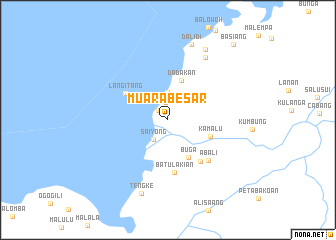
Muarabesar (Sulawesi Tengah, Indonesia)Muarabesar is a town in the Sulawesi Tengah region of Indonesia. An overview map of the region around Muarabesar is displayed below.
regional and 3d topo map of Muarabesar, Indonesia ::
Muarabesar airports ::
The nearest airport is PLW - Palu Mutiara, located 213.7 km south of Muarabesar.
Nearby towns ::
Sikutu (1.5km north west) //
Bilodondo (1.9km north) //
Saiyong (2.7km south west) //
Bilobugis (3.1km north) //
Dadakan (4.7km north) //
Buga (4.7km south east) //
Kamalu (5.1km east) //
Langitang (5.6km north west) //
Batulakian (5.9km south) //
Batuilo (5.9km south east) //
Abali (6.4km south east) //
Tampo (8.1km north east) //
Tengke (8.7km south) //
Dalidi (8.9km north) //
Labuanlobo (8.9km north east) //
Basiang (11.2km north east) //
[all distances 'as the bird flies' and approximate] 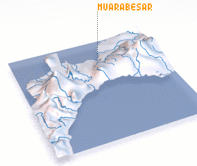 Places with similar names to Muarabesar, Indonesia ::
Disclaimer :: Information on this page comes without warranty of any kind |
||
|
Where is Muarabesar? Elevation and coordinates ::
Latitude (lat): 0°52'26"S Longitude (lon): 120°37'35"E
Elevation (approx.): 24m (map arrows pan, magnifying glasses zoom) |
||
|
Visiting Muarabesar? Hotel/Accommodation ::
Book a hotel in Muarabesar Travel Guide ::
Buy a travel guide for Indonesia rental cars ::
car rental offers GPS waypoint ::
download a GPX waypoint (PoI) of Muarabesar for your GPS receiver
|
||