|
search place name
|
||
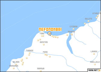
Nefonombai (Nusa Tenggara Timur, Indonesia)Nefonombai is a town in the Nusa Tenggara Timur region of Indonesia. An overview map of the region around Nefonombai is displayed below.
regional and 3d topo map of Nefonombai, Indonesia ::
Nefonombai airports ::
The nearest airport is DIL - Dili Presidente Nicolau Lobato Intl, located 188.5 km north east of Nefonombai.
Nearby towns ::
Bokos (0.6km east) //
Mamlasi (1.1km east) //
Biloka (1.7km east) //
Taloi (1.9km east) //
Maumate (2.6km east) //
Tubufatuknutu (2.7km west) //
Tobu (3.2km west) //
Oenitas (4.0km south west) //
Oekona (4.0km west) //
Nainunus (4.8km west) //
Naktuka (6.1km east) //
Fone (7.1km south) //
Fone (7.2km south) //
Haufua (7.6km south) //
Oehoso (7.7km east) //
Manan (7.9km east) //
Citrana (8.8km east) //
Tuaheo (9.9km south west) //
Tuapala (10.5km south west) //
[all distances 'as the bird flies' and approximate] 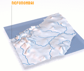 Places with similar names to Nefonombai, Indonesia ::
Disclaimer :: Information on this page comes without warranty of any kind |
||
|
Where is Nefonombai? Elevation and coordinates ::
Latitude (lat): 9°21'3"S Longitude (lon): 124°0'50"E
Elevation (approx.): 16m (map arrows pan, magnifying glasses zoom) |
||
|
Visiting Nefonombai? Hotel/Accommodation ::
Book a hotel in Nefonombai Travel Guide ::
Buy a travel guide for Indonesia rental cars ::
car rental offers GPS waypoint ::
download a GPX waypoint (PoI) of Nefonombai for your GPS receiver
|
||