|
search place name
|
||
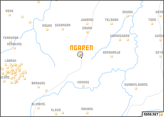
Ngaren (Jawa Tengah, Indonesia)Ngaren is a town in the Jawa Tengah region of Indonesia. An overview map of the region around Ngaren is displayed below.
regional and 3d topo map of Ngaren, Indonesia ::
Nearby towns ::
Gadoh (6.2km north) //
Kemusu (6.4km south) //
Wonoharjo (6.7km east) //
Juwangi (8.1km north) //
Gedangan (8.1km north west) //
Karangsono (9.6km north east) //
Padas (10.3km north west) //
Telawah (10.4km north east) //
Wonosegoro (10.9km south west) //
[all distances 'as the bird flies' and approximate]  Places with similar names to Ngaren, Indonesia ::
// Neugrün (DE)
// Neugrün (DE)
// Neu Göhren (DE)
// Neu Karin (DE)
// Neu Krien (DE)
// Néa Koróni (GR)
// Nekrūnai (LT)
// Negrín (CU)
// Negreni (RO)
// Negreni (RO)
Disclaimer :: Information on this page comes without warranty of any kind |
||
|
Where is Ngaren? Elevation and coordinates ::
Latitude (lat): 7°14'18"S Longitude (lon): 110°44'21"E
Elevation (approx.): 155m (map arrows pan, magnifying glasses zoom) |
||
|
Visiting Ngaren? Hotel/Accommodation ::
Book a hotel in Ngaren Travel Guide ::
Buy a travel guide for Indonesia rental cars ::
car rental offers GPS waypoint ::
download a GPX waypoint (PoI) of Ngaren for your GPS receiver
|
||