|
search place name
|
||
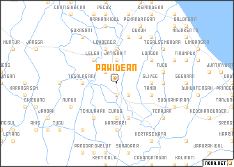
Pawidean (Indonesia)Pawidean is a town in Indonesia. An overview map of the region around Pawidean is displayed below.
regional and 3d topo map of Pawidean, Indonesia ::
Pawidean airports ::
The nearest airport is CGK - Jakarta Soekarno Hatta Intl, located 183.6 km west of Pawidean.
Nearby towns ::
Jatibarang (1.9km south) //
Legok (2.6km north west) //
Sleman (2.6km south east) //
Jatisawit (3.7km north) //
Lelea (5.2km north west) //
Tegalasari (5.5km west) //
Curug (5.6km south) //
Karanggelas (5.6km south) //
Krasak (5.6km north) //
Majasih (5.5km east) //
Sliyeg (5.5km east) //
Lohbener (5.9km north) //
Pilangsari (5.9km south) //
Tambi (5.8km east) //
Temulawak (6.7km south west) //
Longok (6.7km north east) //
Gadingah (7.4km east) //
Wanasari (7.4km south) //
Tugu (7.6km east) //
Sindang (7.6km north) //
Telukagung (7.6km north) //
Nunuk (8.2km south west) //
Dukuh (8.3km north east) //
Sukasari (9.2km north west) //
Rancabugang (9.2km south west) //
Tegalsembadra (9.2km north east) //
Tenajar (9.2km south east) //
Glarmendala (9.2km north east) //
[all distances 'as the bird flies' and approximate] 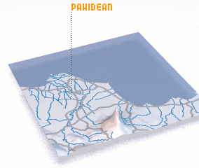
Disclaimer :: Information on this page comes without warranty of any kind |
||
|
Where is Pawidean? Elevation and coordinates ::
Latitude (lat): 6°27'0"S Longitude (lon): 108°17'0"E
Elevation (approx.): 7m (map arrows pan, magnifying glasses zoom) |
||
|
Visiting Pawidean? Hotel/Accommodation ::
Book a hotel in Pawidean Travel Guide ::
Buy a travel guide for Indonesia rental cars ::
car rental offers GPS waypoint ::
download a GPX waypoint (PoI) of Pawidean for your GPS receiver
|
||