|
search place name
|
||
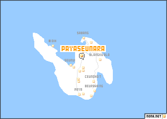
Payaseunara (Aceh, Indonesia)Payaseunara is a town in the Aceh region of Indonesia. An overview map of the region around Payaseunara is displayed below.
regional and 3d topo map of Payaseunara, Indonesia ::
Payaseunara airports ::
The nearest airport is BTJ - Banda Aceh Sultan Iskandarmuda, located 37.9 km south of Payaseunara.
Nearby towns ::
Teupinpuu (1.9km north) //
Cot Damar (1.9km south) //
Blang Garu (2.5km south) //
Alue Primping (2.8km south) //
Prialaot (2.8km south west) //
Aneuk Laot (2.8km north) //
Seurui (3.1km south west) //
Blangkuala (3.7km east) //
Kota Bawah Timur (4.2km north east) //
Batee Shok (4.5km south) //
Sabang (4.9km north) //
Paya Karing (5.1km south) //
Ceunohot (5.5km south east) //
Iboih (7.5km north west) //
Beurawang (7.6km south) //
Keuneukai (7.8km south) //
Paya (7.9km south) //
Meureulo (8.4km south) //
[all distances 'as the bird flies' and approximate] 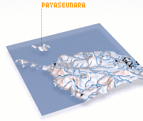 Places with similar names to Payaseunara, Indonesia :: Disclaimer :: Information on this page comes without warranty of any kind |
||
|
Where is Payaseunara? Elevation and coordinates ::
Latitude (lat): 5°51'0"N Longitude (lon): 95°19'0"E
Elevation (approx.): 95m (map arrows pan, magnifying glasses zoom) |
||
|
Visiting Payaseunara? Hotel/Accommodation ::
Book a hotel in Payaseunara Travel Guide ::
Buy a travel guide for Indonesia rental cars ::
car rental offers GPS waypoint ::
download a GPX waypoint (PoI) of Payaseunara for your GPS receiver
|
||