|
search place name
|
||
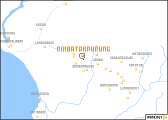
Rimbatampurung (Sumatera Barat, Indonesia)Rimbatampurung is a town in the Sumatera Barat region of Indonesia. An overview map of the region around Rimbatampurung is displayed below.
regional and 3d topo map of Rimbatampurung, Indonesia ::
Rimbatampurung airports ::
The nearest airport is PDG - Padang Tabing, located 108.7 km south east of Rimbatampurung.
Other airports nearby include PKU - Pekanbaru Sultan Syarif Kasim Ii (185.2 km east), DUM - Dumai Pinang Kampai (252.5 km north east), Nearby towns ::
Airparit (1.9km north) //
Wonosari (2.1km west) //
Songaibaku (2.3km south) //
Sumberagung (2.3km south) //
Kampungairputih (2.4km west) //
Tampunik (2.7km north west) //
Pinagar (3.0km east) //
Jambu (3.1km east) //
Silambau (5.3km east) //
Kinali (6.4km east) //
Duriankilangan (8.1km east) //
Kampungkajai (8.3km east) //
Bancahinai (8.6km south east) //
Lubukkarak (9.1km south east) //
Limauabung (9.2km west) //
Alamanda (9.8km south east) //
Sungaibalai (9.9km south east) //
[all distances 'as the bird flies' and approximate] 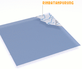 Places with similar names to Rimbatampurung, Indonesia :: Disclaimer :: Information on this page comes without warranty of any kind |
||
|
Where is Rimbatampurung? Elevation and coordinates ::
Latitude (lat): 0°1'46"S Longitude (lon): 99°51'13"E
Elevation (approx.): 34m (map arrows pan, magnifying glasses zoom) |
||
|
Visiting Rimbatampurung? Hotel/Accommodation ::
Book a hotel in Rimbatampurung Travel Guide ::
Buy a travel guide for Indonesia rental cars ::
car rental offers GPS waypoint ::
download a GPX waypoint (PoI) of Rimbatampurung for your GPS receiver
|
||