|
search place name
|
||
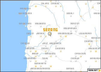
Serang (Indonesia)Serang is a town in Indonesia. An overview map of the region around Serang is displayed below.
regional and 3d topo map of Serang, Indonesia ::
Serang airports ::
The nearest airport is CGK - Jakarta Soekarno Hatta Intl, located 86.3 km east of Serang.
Nearby towns ::
Sikulan (1.8km west) //
Sukasari (2.6km south east) //
Barus (3.7km east) //
Janaka (3.7km west) //
Kaduranca (4.1km south east) //
Jiput (4.1km south west) //
Kadubera (5.2km north west) //
Cilontung (5.5km east) //
Kadubeureum (5.5km east) //
Cening (5.9km south) //
Muruy (5.9km south) //
Ciherang (6.7km south east) //
Gonggong (7.4km south) //
Carita (7.4km west) //
Menes (7.6km south) //
Leuwipatomu (7.6km east) //
Kadupandak (7.6km east) //
Tenjolahang (7.8km south west) //
Sukarame (8.2km north west) //
Badur (9.2km south west) //
Labuhan (9.2km south west) //
Gosali (10.5km north east) //
[all distances 'as the bird flies' and approximate] 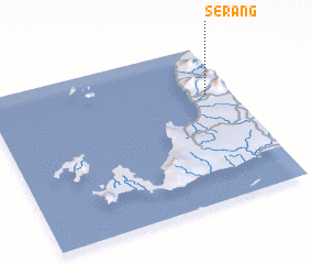 Places with similar names to Serang, Indonesia ::
Disclaimer :: Information on this page comes without warranty of any kind |
||
|
Where is Serang? Elevation and coordinates ::
Latitude (lat): 6°19'0"S Longitude (lon): 105°54'0"E
Elevation (approx.): 225m (map arrows pan, magnifying glasses zoom) |
||
|
Visiting Serang? Hotel/Accommodation ::
Book a hotel in Serang Travel Guide ::
Buy a travel guide for Indonesia rental cars ::
car rental offers GPS waypoint ::
download a GPX waypoint (PoI) of Serang for your GPS receiver
|
||