|
search place name
|
||
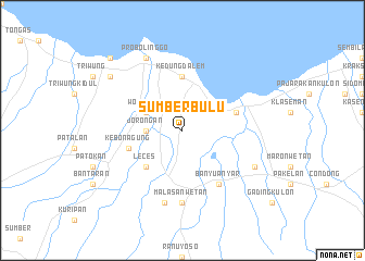
Sumberbulu (Indonesia)Sumberbulu is a town in Indonesia. An overview map of the region around Sumberbulu is displayed below.
regional and 3d topo map of Sumberbulu, Indonesia ::
Nearby towns ::
Jorongan (3.7km west) //
Wonoasih (4.1km north west) //
Leces (5.2km south west) //
Kedungdalem (5.6km north) //
Kebonagung (5.8km west) //
Gending (5.8km east) //
Banyuanyar (6.7km south east) //
Malasan-wetan (7.4km south) //
Malasan-kulon (7.6km south) //
Probolinggo (8.3km north west) //
Jati (8.3km north west) //
Klenang (8.2km south east) //
Kademangan (9.2km north west) //
Pilang (10.4km north west) //
[all distances 'as the bird flies' and approximate]  Places with similar names to Sumberbulu, Indonesia ::
// Somorobalahy (MG)
// Scimber Belei (ET)
// Sumberbuluh (ID)
// Sumurbali (ID)
// Sumāri Bāla (PK)
// Simmerbølle (DK)
Disclaimer :: Information on this page comes without warranty of any kind |
||
|
Where is Sumberbulu? Elevation and coordinates ::
Latitude (lat): 7°49'0"S Longitude (lon): 113°15'0"E
Elevation (approx.): 29m (map arrows pan, magnifying glasses zoom) |
||
|
Visiting Sumberbulu? Hotel/Accommodation ::
Book a hotel in Sumberbulu Travel Guide ::
Buy a travel guide for Indonesia rental cars ::
car rental offers GPS waypoint ::
download a GPX waypoint (PoI) of Sumberbulu for your GPS receiver
|
||