|
search place name
|
||
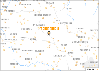
Tagogapu (Jawa Barat, Indonesia)Tagogapu is a town in the Jawa Barat region of Indonesia. An overview map of the region around Tagogapu is displayed below.
regional and 3d topo map of Tagogapu, Indonesia ::
Tagogapu airports ::
The nearest airport is CGK - Jakarta Soekarno Hatta Intl, located 117.5 km north west of Tagogapu.
Nearby towns ::
Warungawi (1.7km south east) //
Ciburuy (2.4km south) //
Panucatan (2.5km south west) //
Kepuh (3.6km south) //
Ngamprah (3.7km south east) //
Padalarang (3.9km south east) //
Cicau (4.3km south) //
Gantungan (4.6km south) //
Nyalindung (4.7km north west) //
Sasaksaat (4.9km north west) //
Cileuleuy (5.3km north) //
Singapura (5.3km west) //
Cirawa (5.4km west) //
Simpang (5.6km south east) //
Dano (5.6km north east) //
Cibogo (6.5km west) //
Pangheotan (6.7km north) //
Cimareme (6.9km south east) //
Warungdomba Dua (7.1km north) //
Cipada (7.2km north east) //
Cilame (7.3km south east) //
Warengkupa (7.4km north east) //
Sukaraja (7.7km east) //
Cileueur (7.9km south west) //
Gadobangkong (8.4km south east) //
Cimangsud (8.6km west) //
Cikalong Wetan (9.6km north west) //
Cibeber-hilir (9.6km south east) //
Jalupang (9.6km south west) //
[all distances 'as the bird flies' and approximate] 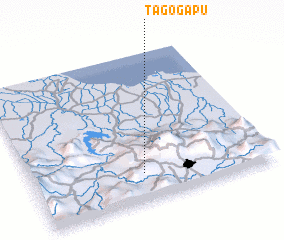 Places with similar names to Tagogapu, Indonesia ::
// Taguaguipe (EC)
// Togakope (GH)
// Tec-cupay (VE)
// Tigkpo (LR)
// Tagkip (PH)
// Tagkip (PH)
// Tagkip (PH)
// Tagugpo (PH)
// Dékou Kopé (TG)
// Dogokopé (TG)
Disclaimer :: Information on this page comes without warranty of any kind |
||
|
Where is Tagogapu? Elevation and coordinates ::
Latitude (lat): 6°48'41"S Longitude (lon): 107°28'3"E
Elevation (approx.): 586m (map arrows pan, magnifying glasses zoom) |
||
|
Visiting Tagogapu? Hotel/Accommodation ::
Book a hotel in Tagogapu Travel Guide ::
Buy a travel guide for Indonesia rental cars ::
car rental offers GPS waypoint ::
download a GPX waypoint (PoI) of Tagogapu for your GPS receiver
|
||