|
search place name
|
||
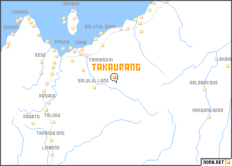
Takaurang (Sulawesi Selatan, Indonesia)Takaurang is a town in the Sulawesi Selatan region of Indonesia. An overview map of the region around Takaurang is displayed below.
regional and 3d topo map of Takaurang, Indonesia ::
Takaurang airports ::
The nearest airport is PLW - Palu Mutiara, located 226.2 km north east of Takaurang.
Other airports nearby include PSJ - Poso Kasiguncu (238.4 km north east), Nearby towns ::
Tammasapi (3.5km north west) //
Salulullung (3.6km west) //
Kelapatujuh (5.6km west) //
Sangkurio (6.4km north west) //
Bayorbayor (6.5km north) //
Danga (7.4km north west) //
Tambi (7.7km north west) //
Tumuki (7.8km north west) //
Padangbaka (8.0km north west) //
Salutalawar (8.3km north) //
Mamuju (8.4km north west) //
Bonebone (8.8km north) //
Manalisse (9.0km north) //
Kasiwa (9.2km north west) //
Ampelas (9.2km north east) //
Rimuku (10.1km north west) //
Karaeang (11.3km north west) //
[all distances 'as the bird flies' and approximate]  Places with similar names to Takaurang, Indonesia ::
Disclaimer :: Information on this page comes without warranty of any kind |
||
|
Where is Takaurang? Elevation and coordinates ::
Latitude (lat): 2°43'27"S Longitude (lon): 118°57'15"E
Elevation (approx.): 303m (map arrows pan, magnifying glasses zoom) |
||
|
Visiting Takaurang? Hotel/Accommodation ::
Book a hotel in Takaurang Travel Guide ::
Buy a travel guide for Indonesia rental cars ::
car rental offers GPS waypoint ::
download a GPX waypoint (PoI) of Takaurang for your GPS receiver
|
||