|
search place name
|
||
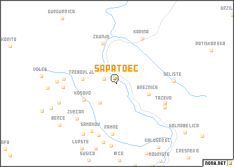
Sapatoec (Macedonia, The Republic of)Sapatoec is a town in Macedonia, The Republic of. An overview map of the region around Sapatoec is displayed below.
regional and 3d topo map of Sapatoec, Macedonia, The Republic of ::
Sapatoec airports ::
The nearest airport is SKP - Skopje, located 43.3 km north east of Sapatoec.
Other airports nearby include OHD - Ohrid (73.4 km south west), PRN - Pristina (91.9 km north), TIA - Tirana Rinas (127.4 km west), KSO - Kastoria Aristotelis (145.3 km south), Nearby towns ::
Blizansko (1.7km north west) //
Brest (3.6km south west) //
Breznica (4.1km south east) //
Trebovlje (4.2km west) //
Kosovo (4.7km south west) //
Zdunje (6.6km north) //
Ramne (8.1km south) //
Kapina (7.8km north east) //
Taževo (6.6km south east) //
(( Gorno Maalo Taževo )) (6.6km south east) //
(( Dolno Maalo Taževo )) (6.8km south east) //
Zvečan (7.4km south west) //
Gorna Reka (6.4km west) //
Rasteš (6.5km west) //
Samokov (8.2km south) //
Dolno Lupšte (8.6km south) //
Kovač (9.1km south west) //
[all distances 'as the bird flies' and approximate] 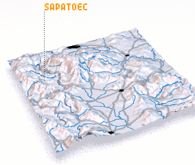 Places with similar names to Sapatoec, Macedonia, The Republic of ::
Disclaimer :: Information on this page comes without warranty of any kind |
||
|
Where is Sapatoec? Elevation and coordinates ::
Latitude (lat): 41°45'8"N Longitude (lon): 21°10'52"E
Elevation (approx.): 429m (map arrows pan, magnifying glasses zoom) |
||
|
Visiting Sapatoec? Hotel/Accommodation ::
Book a hotel in Sapatoec Travel Guide ::
rental cars ::
car rental offers GPS waypoint ::
download a GPX waypoint (PoI) of Sapatoec for your GPS receiver
|
||