|
search place name
|
||
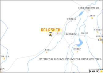
Kolʼashchi (Kökshetaū, Kazakhstan)Kolʼashchi is a town in the Kökshetaū region of Kazakhstan. An overview map of the region around Kolʼashchi is displayed below.
regional and 3d topo map of Kolʼashchi, Kazakhstan ::
Kolʼashchi airports ::
The nearest airport is ALA - Alma-ata Almaty, located 35.7 km east of Kolʼashchi.
Nearby towns ::
 Places with similar names to Kolʼashchi, Kazakhstan ::
// Galishchi (RU)
// Kalishche (RU)
// Kalishchi (RU)
// Koloshichi (RU)
// Kallichchai (LK)
// Kelāsh Hūsh (IR)
// Qelīch Chī (IR)
// Kāla Chechi (PK)
// Khylʼchychi (UA)
// Qal‘eh Shīsheh (IR)
Disclaimer :: Information on this page comes without warranty of any kind |
||
|
Where is Kolʼashchi? Elevation and coordinates ::
Latitude (lat): 43°22'0"N Longitude (lon): 76°36'0"E
Elevation (approx.): 686m (map arrows pan, magnifying glasses zoom) |
||
|
Visiting Kolʼashchi? Hotel/Accommodation ::
Book a hotel in Kolʼashchi Travel Guide ::
Buy a travel guide for Kazakhstan rental cars ::
car rental offers GPS waypoint ::
download a GPX waypoint (PoI) of Kolʼashchi for your GPS receiver
|
||