|
search place name
|
||
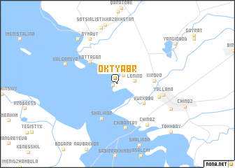
Oktyabr' (Kökshetaū, Kazakhstan)Oktyabr' is a town in the Kökshetaū region of Kazakhstan. An overview map of the region around Oktyabr' is displayed below.
regional and 3d topo map of Oktyabr', Kazakhstan ::
Oktyabr' airports ::
The nearest airport is TAS - Tashkent Yuzhny, located 60.3 km north east of Oktyabr'.
Other airports nearby include CIT - Chimkent Shymkent (168.9 km north east), SKD - Samarkand (201.1 km south west), Nearby towns ::
Imeni Lenina (0.6km south west) //
Birlik (1.6km north east) //
Lenino (2.2km east) //
Kurkaba (4.5km south east) //
Kattagan (4.8km north west) //
Kirovo (4.5km east) //
Shalikor (5.9km south) //
Dzhaldama (5.5km south east) //
Chibantay (7.1km south) //
Yallama (5.8km east) //
Chinaz (7.5km south east) //
Oymaut (7.9km north west) //
Kalgansyr (6.9km north west) //
Novyy Chinaz (7.6km south east) //
Ani-Muratbay (8.5km north west) //
Tokhbay (10.1km south east) //
[all distances 'as the bird flies' and approximate]  Places with similar names to Oktyabr', Kazakhstan ::
Disclaimer :: Information on this page comes without warranty of any kind |
||
|
Where is Oktyabr'? Elevation and coordinates ::
Latitude (lat): 40°58'9"N Longitude (lon): 68°40'22"E
Elevation (approx.): 260m (map arrows pan, magnifying glasses zoom) |
||
|
Visiting Oktyabr'? Hotel/Accommodation ::
Book a hotel in Oktyabr' Travel Guide ::
Buy a travel guide for Kazakhstan rental cars ::
car rental offers GPS waypoint ::
download a GPX waypoint (PoI) of Oktyabr' for your GPS receiver
|
||