|
search place name
|
||
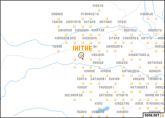
Ihithe (Central, Kenya)Ihithe is a town in the Central region of Kenya. An overview map of the region around Ihithe is displayed below.
regional and 3d topo map of Ihithe, Kenya ::
nearby GPS traces from timatio ::
Ihithe airports ::
The nearest airport is WIL - Nairobi Wilson, located 92.9 km south of Ihithe.
Other airports nearby include EDL - Eldoret Intl (206.1 km north west), KTL - Kitale (266.5 km north west), Nearby towns ::
Githerere (0.0km north) //
Gathuthi (1.9km east) //
Gatumbiru (1.9km north) //
Munyange Two (1.9km south) //
Huguini (1.9km west) //
Wandumbi (2.6km north east) //
Munyange One (2.6km south east) //
Njigari (2.6km south west) //
Kagioini (3.7km east) //
Ichagichiru (3.7km north) //
Githugi (3.7km south) //
Githakwa (4.1km north east) //
Kagundu (4.1km north east) //
Kigogo-ini (4.1km north east) //
Hatha-ini (4.1km south east) //
Mahiga (4.1km south east) //
Gaturi (4.1km north west) //
Kihome (4.1km south east) //
Kianderi (5.2km north east) //
Kiandongoro (5.2km north west) //
Konyu (5.6km south) //
Kirurumi (5.6km north) //
Kagwathi (5.9km east) //
Kairuthi (5.9km south) //
Ihua (5.9km north) //
Kinunga (5.9km north) //
Tusha (5.9km west) //
Gathumbi (6.7km south east) //
Kihatha (6.7km north east) //
[all distances 'as the bird flies' and approximate]  Places with similar names to Ihithe, Kenya :: Disclaimer :: Information on this page comes without warranty of any kind |
||
|
Where is Ihithe? Elevation and coordinates ::
Latitude (lat): 0°29'0"S Longitude (lon): 36°52'0"E
Elevation (approx.): 2126m (map arrows pan, magnifying glasses zoom) |
||
|
Visiting Ihithe? Hotel/Accommodation ::
Book a hotel in Ihithe Travel Guide ::
Buy a travel guide for Kenya rental cars ::
car rental offers GPS waypoint ::
download a GPX waypoint (PoI) of Ihithe for your GPS receiver
|
||