|
search place name
|
||
Kabartonjo (Rift Valley, Kenya)Kabartonjo is a town in the Rift Valley region of Kenya. An overview map of the region around Kabartonjo is displayed below.
regional and 3d topo map of Kabartonjo, Kenya ::

Kabartonjo airports ::
The nearest airport is EDL - Eldoret Intl, located 67.4 km west of Kabartonjo.
Other airports nearby include KTL - Kitale (100.9 km west), KIS - Kisumu (143.3 km south west), WIL - Nairobi Wilson (243.9 km south east), Nearby towns ::
Kapchepkor (1.9km south) //
Tiriondonin (3.7km west) //
Kasisit (3.7km east) //
Tirimionin (4.1km north east) //
Serkongun (5.2km south west) //
Kapkiam (5.2km north west) //
Talai (5.6km south) //
Bartolimo (5.9km north) //
Kipcherere (7.9km south east) //
Pemwai (8.3km south west) //
Kaption (10.5km north west) //
[all distances 'as the bird flies' and approximate] 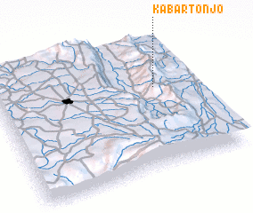 Places with similar names to Kabartonjo, Kenya ::
// Quebrada Ñajú (PA)
// Gobertange (BE)
Disclaimer :: Information on this page comes without warranty of any kind |
||
|
Where is Kabartonjo? Elevation and coordinates ::
Latitude (lat): 0°38'0"S Longitude (lon): 35°48'0"E
Elevation (approx.): 2226m (map arrows pan, magnifying glasses zoom) |
||
|
Visiting Kabartonjo? Hotel/Accommodation ::
Book a hotel in Kabartonjo Travel Guide ::
Buy a travel guide for Kenya rental cars ::
car rental offers GPS waypoint ::
download a GPX waypoint (PoI) of Kabartonjo for your GPS receiver
|
||