|
search place name
|
||
Kihome (Central, Kenya)Kihome is a town in the Central region of Kenya. An overview map of the region around Kihome is displayed below.
regional and 3d topo map of Kihome, Kenya ::

Kihome airports ::
The nearest airport is WIL - Nairobi Wilson, located 89.7 km south of Kihome.
Other airports nearby include EDL - Eldoret Intl (212.7 km north west), KTL - Kitale (273.1 km north west), Nearby towns ::
Kagonye (0.0km north) //
Rukira (2.6km south east) //
Gathumbi (2.6km south west) //
Hatha-ini (2.6km north west) //
Mahiga (2.6km north west) //
Thunguri (3.7km south) //
Birithia (3.7km east) //
Kihome (3.7km west) //
Gatuyaini (4.1km south east) //
Kagere (4.1km north east) //
Kairuthi (4.1km south west) //
Kagioini (4.1km north west) //
Munyange One (4.1km north west) //
Kianganda (5.2km south east) //
Gachatha (5.2km north east) //
Kariguini (5.2km north east) //
Ihuririo (5.2km south west) //
Gathuthi (5.2km north west) //
Gatugi One (5.6km east) //
Githugi (5.6km west) //
Gatundu (5.6km south) //
Gachichi (5.6km south) //
Kagwathi (5.6km north) //
Konyu (5.9km west) //
Gatugi Two (5.9km east) //
Huho-ini (5.9km south) //
Wamagana (5.9km north) //
Munyange Two (5.9km west) //
Githakwa (5.9km north) //
[all distances 'as the bird flies' and approximate] 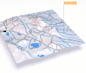 Places with similar names to Kihome, Kenya ::
Disclaimer :: Information on this page comes without warranty of any kind |
||
|
Where is Kihome? Elevation and coordinates ::
Latitude (lat): 0°31'0"S Longitude (lon): 36°55'0"E
Elevation (approx.): 1906m (map arrows pan, magnifying glasses zoom) |
||
|
Visiting Kihome? Hotel/Accommodation ::
Book a hotel in Kihome Travel Guide ::
Buy a travel guide for Kenya rental cars ::
car rental offers GPS waypoint ::
download a GPX waypoint (PoI) of Kihome for your GPS receiver
|
||