|
search place name
|
||
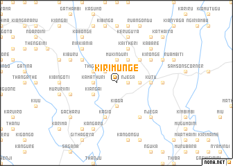
Kirimunge (Central, Kenya)Kirimunge is a town in the Central region of Kenya. An overview map of the region around Kirimunge is displayed below.
regional and 3d topo map of Kirimunge, Kenya ::
Kirimunge airports ::
The nearest airport is WIL - Nairobi Wilson, located 97.5 km south west of Kirimunge.
Nearby towns ::
Njega (1.9km east) //
Kiamuthambi (1.9km east) //
Barisho (2.6km north west) //
Gatuto (3.7km east) //
Kiaga (3.7km south) //
Mukinduri (3.7km north) //
Kamathuri (3.7km west) //
Kiamwenja (4.1km north east) //
Kiangai (4.1km south west) //
Thiguku (4.1km north west) //
Karia (5.2km north east) //
Kutu (5.6km east) //
Kaitheri (5.9km north) //
Kagio (5.9km south) //
Kangai (6.7km south east) //
Kirongʼe (6.7km north east) //
Gatuya (6.7km north west) //
Gakuo (7.4km east) //
Gatithi (7.6km west) //
Keruguya (7.6km north) //
Kabare (7.9km north east) //
Njega (7.9km south east) //
Riakiania (7.9km north west) //
Rukenya (8.3km north east) //
Kangaru (8.3km south west) //
Kianjiru (8.3km north west) //
Kiburu (8.3km north west) //
Gacharu (9.3km south west) //
Ithareni (9.3km north east) //
[all distances 'as the bird flies' and approximate] 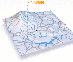 Places with similar names to Kirimunge, Kenya ::
Disclaimer :: Information on this page comes without warranty of any kind |
||
|
Where is Kirimunge? Elevation and coordinates ::
Latitude (lat): 0°34'0"S Longitude (lon): 37°16'0"E
Elevation (approx.): 1341m (map arrows pan, magnifying glasses zoom) |
||
|
Visiting Kirimunge? Hotel/Accommodation ::
Book a hotel in Kirimunge Travel Guide ::
Buy a travel guide for Kenya rental cars ::
car rental offers GPS waypoint ::
download a GPX waypoint (PoI) of Kirimunge for your GPS receiver
|
||