|
search place name
|
||
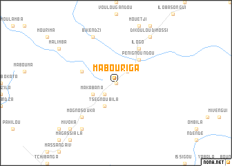
Mabouriga (Nyanga, Gabon)Mabouriga is a town in the Nyanga region of Gabon. An overview map of the region around Mabouriga is displayed below.
regional and 3d topo map of Mabouriga, Gabon ::
Mabouriga airports ::
The nearest airport is OMB - Omboue Hospial Omboue Hopital, located 244.4 km north west of Mabouriga.
Nearby towns ::
Massoli Oubala (0.0km north) //
Nvounda (2.6km north east) //
Divangui (2.6km north east) //
Missigou (2.6km north east) //
Mouringa Issenguele (2.6km south west) //
Boungou Bouliba (2.6km south west) //
Tando Filou (2.6km south west) //
Makabana (4.1km south west) //
Tsegnou Bila (4.1km south west) //
Issibou (5.2km north east) //
Peni Gnoundou (5.2km north east) //
Irendou (5.9km west) //
Doussoundzi (6.7km north east) //
Ilogo (6.7km north east) //
Keri Nzambi (7.9km south west) //
Mogno Souka (7.9km south west) //
Ikeri Issiana (7.9km south west) //
Bikendzi (8.3km north west) //
Dikoulou Dimossi (9.3km north east) //
Iloumi Ilongo Dibora (9.3km south west) //
Mivoka (10.5km south west) //
[all distances 'as the bird flies' and approximate] 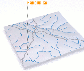 Places with similar names to Mabouriga, Gabon ::
Disclaimer :: Information on this page comes without warranty of any kind |
||
|
Where is Mabouriga? Elevation and coordinates ::
Latitude (lat): 2°44'0"S Longitude (lon): 11°8'0"E
Elevation (approx.): 315m (map arrows pan, magnifying glasses zoom) |
||
|
Visiting Mabouriga? Hotel/Accommodation ::
Book a hotel in Mabouriga Travel Guide ::
Buy a travel guide for Gabon rental cars ::
car rental offers GPS waypoint ::
download a GPX waypoint (PoI) of Mabouriga for your GPS receiver
|
||