|
search place name
|
||
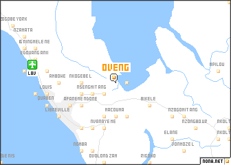
Oveng (Estuaire, Gabon)Oveng is a town in the Estuaire region of Gabon. An overview map of the region around Oveng is displayed below.
regional and 3d topo map of Oveng, Gabon ::
Oveng airports ::
The nearest airport is LBV - Libreville Leon M Ba, located 13.8 km west of Oveng.
Other airports nearby include LBQ - Lambarene (148.7 km south east), POG - Port Gentil (153.5 km south west), BSG - Bata (165.6 km north), BMM - Bitam (283.8 km north east), Nearby towns ::
Les Bambous (1.9km east) //
Sibang (2.6km south west) //
Nseng-Mitang (4.1km south west) //
Macouma (5.6km south) //
Nkog Ebel (5.6km west) //
Nzong-Ayong (5.6km west) //
Ilou (5.9km south) //
Atouda-Simba (5.9km west) //
Assougoula Emo (5.9km west) //
Bizango-Bibéré (5.9km south) //
Bikelé (6.7km south east) //
Afane-Mendone (6.7km south west) //
Nvanayémé (7.6km south) //
Mindoube (8.3km south west) //
Adzébé (8.3km south west) //
Atonda-Simba (8.3km south west) //
Lalala (9.3km south west) //
[all distances 'as the bird flies' and approximate] 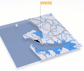 Places with similar names to Oveng, Gabon ::
Disclaimer :: Information on this page comes without warranty of any kind |
||
|
Where is Oveng? Elevation and coordinates ::
Latitude (lat): 0°26'0"S Longitude (lon): 9°32'0"E
Elevation (approx.): 13m (map arrows pan, magnifying glasses zoom) |
||
|
Visiting Oveng? Hotel/Accommodation ::
Book a hotel in Oveng Travel Guide ::
Buy a travel guide for Gabon rental cars ::
car rental offers GPS waypoint ::
download a GPX waypoint (PoI) of Oveng for your GPS receiver
|
||